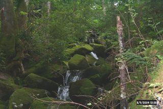
Tellico River

Nationally recognized as a premier trout stream, the Tellico River in Monroe County, Tennessee, is a freestone stream located within the heart of The Cherokee National Forest. Its headwaters begin in North Carolina and flow for almost twenty miles to Tellico Plains.
The main stream of Tellico River is heavily stocked by the state and requires a special permit to fish. It’s a very large freestone mountain stream with a network of fine native trout laden tributaries. The Tellico River is spotted with a few wild trout mixed in its waters, with the heaviest concentration of natives in its upper section. For the fly fisherman the rivers best assets are its smaller, wild trout streams that contain native brook, rainbow and brown trout.
Stocked Areas:
Tellico River-from its confluence with Turkey Creek upstream to the Tennessee-North Carolina state line.
Citico Creek- from its confluence with Little Citico Creek upstream to the confluence of North and South Forks of Citico Creek.
Tellico-Citico Permit required March 1 through Aug. 15. to fish in stocked areas.
Closed on Thursday and Friday during the period March 1 through Aug. 15 (except when national or state holidays fall on Thursday and Friday). From Aug. 16 through the last day of February fishing is allowed every day and the Tellico Citico Permit is not required.
Fishing permitted 1/2 hour before official sunrise to 1/2 hour after official sunset. The possession of fishing equipment and/or tackle is prohibited on stream banks except during legal fishing hours.
Each angler is permitted only one rod or pole.
Free Fishing Day
Tellico River from Sourwood Campground upstream to the dam on Tellico River from 1/2 hour before official sunrise to 12pm closed to fishing for individuals 17 and older on Free Fishing Day.
Delayed Harvest Regulations (Tellico River):
From the Mouth of North River upstream to the Tennessee-North Carolina state line.
Catch-and-release season begins Oct. 1 through last day of Feb.
The harvest or possession of trout is prohibited during the catch-and-release season. During the catch-and-release season, only artificial lures are permitted and the use or possession of bait is prohibited.
Citico Creek

Nestled in the heart of the Cherokee National Forest, Citico Creek in Tennessee offers a serene and picturesque setting for anglers of all levels. Surrounded by lush forestry, crystal-clear waters, and a peaceful ambiance, this creek is a hotspot for fishing enthusiasts looking to hook their next big catch. Whether you’re a beginner or a seasoned pro, Citico Creek promises a rewarding and unforgettable experience.
Citico Creek is known for its pristine waters and enchanting natural beauty. As you fish, you’ll be enveloped in the calming sounds of the creek and the vibrant colors of the surrounding forest, making it a perfect retreat from the hustle and bustle of everyday life. With its diverse ecosystem, Citico Creek supports a rich variety of fish species, offering endless opportunities for anglers to reel in something special.
Whether you’re aiming for a trophy fish or want to enjoy a leisurely day of angling, understanding the fish species in Citico Creek is crucial. Here’s a breakdown of the popular species you’ll encounter.
North River

The North River, tributary to the Tellico River, is an excellent brown trout stream. Do not be fooled by the size of the North River it is small but contains very large brownies. The upper section is a source of wild rainbows as well as native brook trout. The headwaters for the North River are located to the south side of The Cherohala and you can access the upper sections of the North river from the trails off this wonderful scenic byway.
Bald River

Bald River is a tributary stream to the Tellico River in the Cherokee National Forest (Bald River Falls and Big Junction Quad Maps). It is easy to access from Forest Service trail 88 through Bald River Gorge Wilderness or along Forest Service Road 126 south of the Wilderness or by hiking up Forest Service Trails 180 and 2. Above the Brookshire Creek confluence, you will be in a large cove with the trail gradually climbing the valley wall and leaving the stream. The stream has only southern strain brook trout.
There are about 2.5 miles of fishable water with no steep, cascades or waterfalls. Plan to camp or leave yourself plenty of time to get out. It’s a long hike but the trail is not steep or rough. Bald River is a tributary to the Tellico River/Little Tennessee River in the Cherokee National Forest (Bald River Falls and Big Junction Quad Maps). Its headwaters are over 4200 feet in elevation with the highest area being on Beaverdam Bald (4259 feet). Access to this stream is variable depending on where you want to go. At its confluence with Tellico River, Bald River is has a large and well known waterfall. A hiking trail follows the river above the falls through the Bald River Gorge Wilderness where the river is wide and flat. An occasional waterfall requires climbing but more flat, open water lies above. Two people can fish the entire Wilderness portion (3.7 miles) in a single long day by parking a car at the top end and driving around to the falls. Rainbow trout will dominate your catch. I have never caught brown or brook trout in this reach.
Above the Wilderness, Forest Service Road 126 parallels the river for about 1.3 miles to Henderson Branch. This stretch of river is very flat and open. Casting is easy and it is a great place to teach someone to trout fish. Rainbow trout are dominant but brown trout are not uncommon and an occasional brook trout is present. Above Henderson Branch, Bald River gets a little smaller in size and access is limited to Forest Service trail (180). Horses are allowed on this trail. These two miles of river contain the same mix of species as below except the brook trout become more abundant. This stretch is an excellent area to try to catch all three species of trout in one day.
At the confluence with Brookshire Creek, the trail continues up Bald River for about for about 1.5 miles where it crosses the stream and leaves the valley. The gradient increases and the river gets smaller. I have not seen any significant waterfalls in this stretch. The valley is wide with the trail high above it. Only brook trout are present; the southern strain of brook trout. Fishable water continues above the trail crossing for about a mile.
Access Bald River from the Tellico River Road (Forest Service Road 210). Park at the falls and hike up the trail into Bald River Gorge Wilderness. Another good trip for one or two people is to park at the bridge on FSR 126 and hike down into the Wilderness. Access between the bridge and Henderson Branch confluence is excellent because FSR 126 follows the stream very closely. Finally, to access the upper reaches, park at Henderson Branch and hike Forest Trail 180. It is two miles to the Brookshire Creek confluence with one ford. Current regulations allow year-round fishing with flies and lures only.
Sycamore Creek

Sycamore Creek is a tributary stream to the Tellico River in the Cherokee National Forest (Big Junction Quad Map). It is easy to access from Forest Service trail 163; southern strain brook trout become abundant about 2 miles upstream of the confluence. There are no significant waterfalls until you get to the very upper end of the stream where the brook trout are. Even these falls are only about 10 to 15 feet high. There are about 4 miles of fishable water in Sycamore Creek; it has a trail with and easy grade beside it most of its length.
Sycamore Creek is a tributary to the Tellico River/Little Tennessee River in the Cherokee National Forest (Big Junction Quad Map). Its headwaters are over 5000 feet in elevation with the highest area being on Haw Knob (5470 feet). Sycamore Creek has its confluence with Tellico River at 2100 feet in elevation. A hiking trail (FST 163) follows the creek at a nice even grade for about 1.8 miles. After that the trail has some switchbacks and gets away from the stream for about 1.5 miles. It returns to the streamside but leaves it almost immediately as it proceeds to Forest Service Road 61.
From the Tellico River upstream for about 1.8 miles, Sycamore Creek is a moderate sized creek – about 10 to 15 feet wide; the gradient averages about 6.5%. It is relatively open making casting, especially roll-casting, fairly easy. The rainbow trout are numerous in this reach and easy to catch. Above the confluence with Mangum Branch, the stream gradient gets steeper and the channel narrows down. Brook trout become more plentiful in this section. The channel gets smaller over the next 1.5 miles with bedrock and large boulders dominating the substrate. The trail returns to the stream side at this point. Several bedrock waterfalls isolate the brook trout from rainbow trout in this area.
In the 1990’s the Forest Service, Tennessee Wildlife Resources Agency, and Trout Unlimited rebuilt the barrier used to divert water into the Pheasant Fields Fish Rearing Facility. The dam could, eventually, be used as barrier to keep rainbow trout and other species out of Sycamore Creek if the entire stream were renovated for brook trout. Sycamore Creek could become one of the largest streams with southern strain brook trout providing a key source for future re-stocking efforts.
This stream is fairly open for casting throughout its length. Dry flies are always taken in Sycamore Creek regardless of the month of the year. Beginners should really enjoy the lower stretch with its openness and abundance of trout. The upper stretch is a physical climb with much rock scrambling required; also, the remoteness of the upper reach makes it a bit dangerous for inexperienced climbers.
Access Sycamore Creek from the Tellico River Road (Forest Service Road 210). Park in the parking lot beside the bridge that crosses the Tellico River and goes to the fish hatchery. Walk across the bridge and turn right up the trail (FST 163) beside Sycamore Creek. The trial stays beside the stream for 1.8 providing ample fishing for a single day with several anglers but the brook trout are rare in this reach. You can also access Sycamore Creek higher up by driving up North River Road (FSR 217) to the juncture with FSR 61. Follow FSR 61 for about 2 miles to FST 163. The hike down the trail is about 2 miles but it brings you into the stretch of stream that contains only southern strain of brook trout – and lots of them.
Big Cove Branch

Big Cove Branch is a tributary stream to North River in the Cherokee National Forest (Big Junction Quad Map). It is easy to access at the lower end but most of the brook trout are over three quarters of a mile upstream. Getting back to your starting point on North River involves a long hike if you go above the waterfalls to catch brook trout. The two major waterfalls on this stream are spectacular. The stream recently underwent some rehabilitation which involved trimming the thick rhododendron to improve the stream flow and angler access.
Big Cove Branch is a tributary stream to North River/Tellico River/Little Tennessee River in the Cherokee National Forest (Big Junction Quad Map). Its headwaters are over 4000 feet in elevation with the highest area being on Whigg Ridge between Whigg Meadow and Deep Gap (4030 feet). This stream is easy to accessed but getting out can take a long, cross country hike.
From its mouth to its headwaters, Big Cove Branch was plagued with continuous, dense stands of rhododendron. The rhododendron was so dense that it extended completely across the channel blocking the stream flows and anglers. The Appalachian Chapter of Trout Unlimited and the US Forest Service expended considerable effort to open the stream channel by trimming back the rhododendron. After the project was completed in 2006, Big Cove Branch flowed in its natural channel, scoured out sediment that had deposited behind the rhododendron obstructions, restored deep pools, and provided access and fishing opportunities for anglers.
The stream flows into the North River at about 2060 feet. From its confluence with North River upstream for about 0.6 miles, Big Cove Branch has a boulder and gravel stream bottom with very dense rhododendron on both sides of the channel. Above this stretch are two significant waterfalls (both are over 30 feet high). The first waterfall flows over a wide bedrock lip then cascades through some rubble. It has no plunge pool. The second waterfall is one of the most unusual I have ever seen. It consists of a narrow chute that is perpendicular to the stream channel for the first 20 feet then plunges into a nice pool. Climbing these waterfalls is not too difficult but they should be regarded as very dangerous and great caution is recommended. Above these waterfalls the channel returns to a boulder and gravel substrate with occasional bedrock outcrops. Fishable water extends for another 0.7 miles.
Access Big Cove Branch off North River Road (Forest Service Road 217) at the parking area for the Donley Cabin. Cross North River and follow the trail (approximately 0.1 mile) to Big Cove Branch. The lower reach contains both rainbow and brook trout and is fairly easy to get into and out of. About 0.3 miles up stream of the confluence there is an opening cut through the rhododendron that accesses a wildlife opening with a road back to the North River confluence. The next exit point from the stream channel is above the waterfalls where Forest Service Road 2417 (closed to public motorized access) comes close to the stream. Again a path has been cut through the rhododendron out to the road. The final exit is at the culvert where Big Cove Branch goes under FSR 2417. To get back down to the confluence, follow this road westward to until you get above the Donley Cabin. An old trail used to connect FSR 2417 to the cabin but it is no longer maintained. If you keep good track of where you are on the road, you will be able to get back to the cabin without the trail.
Brook trout occur throughout Big Cove Branch but are most numerous above the waterfalls which exclude the rainbow trout. Since the rhododendron trimming project, both the rainbow and brook trout populations have expanded significantly and a good angler should catch plenty of each species. Current regulations allow year-round fishing with flies and lures only.
Brookshire Creek

Brookshire Creek is a tributary stream to Bald River in the Cherokee National Forest (Bald River Falls and Unaka Quad Maps). It is easy to access from Forest Service trail 180 that starts where FS Road 126 first comes down to the Bald River. Once you get to Brookshire Creek, you will be in large, open valley or cove with excellent camping sites amid the large poplars. The stream has only brook trout in it and they are plentiful. There are about 3 miles of fishable water with no steep, cascades or waterfalls. Getting back to your vehicle will take some time because of the distance but the trail is an old railroad grade that has a gentle 3% slope almost the whole length.
Brookshire Creek is a tributary stream to Bald River/Tellico River/Little Tennessee River in the Cherokee National Forest (Bald River Falls and Unaka Quad Maps). Its headwaters are over 4200 feet in elevation with the highest area being on Beaverdam Bald (4259 feet). Access to this stream requires a 2 mile hike up an excellent Forest Service trail (180). Horses are allowed on this trail. At the confluence with Bald River, the trail continues up Brookshire Creek all the way to its headwater springs at Sled Runner Gap between Rocky Top and Beaverdam Bald.
A small stream, Brookshire Creek widths are generally less than 12 feet. Up high the width narrows to only a few feet but because of the spring influence brook trout are present well beyond where anglers can easily step across the entire channel. Rhododendron is often thick, especially on the upper end. The trail has tunnels hewn through this prolific shrub.
Brookshire Creek does not have any waterfalls on it that are of any consequence. Just down stream of its confluence with Bald River, a series of waterfalls (one as high as 15 feet) form a barrier to upstream migration of rainbow and brown trout. The gradient of the stream is consistently about 8% with no flats or exceptionally steep areas.
At its confluence with Bald River, Brookshire Creek is about 2100 feet in elevation. For the next 1.7 miles the stream flows through a wide valley with many flat areas suitable for camping. The open understory beneath the huge poplar trees makes this rich cove setting very inviting. Once the stream turns southeastward the valley narrows down and the rhododendron becomes impassable. If you want to work at it, the fishable water extends for another 1.3 miles.
Rainbow trout were the only fish present in Brookshire Creek prior to 1982 having been stocked there during the 1930’s following the extirpation of the native brook trout by exploitation logging. In the fall of that 1982 the Tennessee Wildlife Resources Agency and US Forest Service attempted to replace the rainbow trout with brook trout. Electrofishing and creosol were used to remove the rainbow trout. Brook trout were brought in from upper Bald River (pure southern strain) and Henderson Branch (hybrid of northern and southern strains). At the time the southern strain of brook trout was not recognized and mixing of brook trout from different areas was common. The effort failed to eliminate the rainbow trout but brook trout were successfully established. In 1989 and 1990 a second effort at removing rainbow trout was made by TWRA, USFS and Trout Unlimited. This effort was a success and today Brookshire Creek contains only brook trout.
Access Brookshire Creek off Bald River Road (Forest Service Road 126) at the confluence of Bald River and Henderson Branch. A FS horse trail (open to use by hiker, too) parallels the streams for about 2 miles. About half way up the trail it fords Bald River. As you approach the Brookshire Creek confluence with Bald River, there is a series of waterfalls – each a little higher than the previous. The last is about 15 feet high. These waterfalls prevent the brown and rainbow trout in Bald River from entering Brookshire Creek. Abundant numbers of brook trout occur in this fine stream. If you camp in the beautiful cove, it is entirely appropriate to have a brook trout dinner. Otherwise, turn them loose because they will not remain fresh on the long hike back to your vehicle.
Current regulations allow year-round fishing with flies and lures only.
Falls Branch

Falls Branch is a tributary stream to Citico Creek in the Citico Creek Wilderness Area of the Cherokee National Forest (Whiteoak Flats and Big Junction Quad Map). It has stretches that are difficult to access but also an area that is easily accessed. The difficult stretches do not have a trail associated with them. Brook trout are present in the entire stream but rainbow trout dominate in the lower stretches. Falls Branch is a beautiful stream with a spectacular waterfall and many large, old growth trees.
Falls Branch is a tributary stream to South Fork of Citico Creek/Citico Creek/Little Tennessee River in the Cherokee National Forest (Whiteoak Flats and Big Junction Quad Maps). It flows through the only virgin (never harvested) timber stand known on this Forest and has a beautiful namesake waterfall. Falls Branch is entirely within the Citico Creek Wilderness where its headwaters (Bob Bald) are over 5000 feet in elevation. This stream is both remote and easily accessed. A two mile trail from Rattlesnake Rock Observation Site leads to the falls but access upstream or downstream is extremely difficult.
The stream combines with the South Fork of Citico Creek at about 2880 feet. From its confluence with South Fork of Citico Creek upstream for about one and a quarter miles (no trail), Falls Branch is a series of low (usually less than 12 feet high), bedrock waterfalls. Above this stretch, the stream flattens out and continues to be difficult to climb because of the large quantities of down timber. Some logs are over 3 feet in diameter! After about a half mile you will reach the trail leading to the 40 falls that is in a deep gorge. The reason this area was never harvested becomes obvious. There was no easy way to get into it from above or from below with a railroad line. Above the falls (a very dangerous climb) Falls Branch enters Jeffery Hell. The rhododendron is so thick for the next mile and a quarter that you will be crawling more than walking and the fishing will be difficult. If you continue through Jeffrey Hell, you will eventually come to trail 196 which will lead you back to Rattlesnake Rock Observation Site. This area is called Jeffrey Hell after a fellow who wandered in there and never came out. There is no good reason for going in!
The first 1.75 miles of Falls Branch is fishable with the better water occurring with the small waterfalls in the lowest reach. Both rainbow and brook trout are present from the confluence up to the big waterfalls. The average gradient is 10% below the falls with channel widths of 10 to 15 feet except at the falls where it is quite wide. Some pools are up to 4 feet deep. Above the falls, the stream is split into multiple channels that are so densely covered in rhododendron that you either walk on top of it or crawl through it. Gradient averages 5%. Only brook trout (northern strain) are present above the falls.
Falls Branch is close to the Cherohala Skyway (State Highway 165) with a trail (Forest Service trail 87) leading from Rattlesnake Rock Observation Site to the waterfalls (approximately 2 miles). Most of the trail is an old road bed and is easy to walk. The last half mile is a steep trail that winds through some beautiful old growth trees before crossing Falls Branch and climbing to base of the falls. There is no trail upstream or downstream of the falls. To access the lower stretch, follow Forest Service Trail 196 from Rattlesnake Rock Observation Site (for about 3 miles) to Forest Service Trail 105 which parallels the South Fork of Citico Creek. Continue down this trail about 2 miles and cut down the hillside to the confluence. If you are going to do this route, plan for a full day (12 hours plus) of hiking and climbing. Access to Falls Branch above the falls is best (if there is any good way) from where trail 196 crosses it; but you will immediately be struggling through the rhododendron. Current regulations allow year-round fishing with no special gear restrictions.
Henderson Branch

Henderson Branch is a tributary stream to Bald River in the Cherokee National Forest (Bald River Falls Quad Map). It is easy to access at the lower end with FSR 126 paralleling the stream for about 2 miles. Getting back to your starting point on FSR 126 can be a little difficult because of the steep road bank and thick rhododendron along the stream. There are no major waterfalls on this stream but a concrete dam serves as a barrier to separate the brook trout from the rainbow and brown trout. The stream recently underwent some rehabilitation which involved trimming the thick rhododendron to improve the stream flow and angler access.
Henderson Branch is a tributary stream to Bald River/Tellico River/Little Tennessee River in the Cherokee National Forest (Bald River Falls Quad Map). Its headwaters are over 3600 feet in elevation with the highest area being on Sugar Mountain (3600 feet). This stream is easy to access from its mouth and upstream for about 2 miles (to the confluence with Ellis Branch). Above this confluence, Henderson Branch gets away from Forest Service Road 126 and travel becomes difficult.
Henderson Branch is a small stream; widths are generally less than 20 feet. It has a low gradient throughout the fishable extent and is probably the flatest brook stream in the Tellico area. From its mouth to its headwaters, Henderson Branch is plagued with continuous, dense stands of rhododendron. The rhododendron extends completely across the channel blocking the stream flows and anglers. In 2006 the US Forest Service opened up a portion of the stream channel (between Skull Branch and Ellis Branch) by trimming back the rhododendron. Access is much improved as is the physical habitat within the stream channel. Spawning gravels that had been buried by sediment are now exposed and shine brightly against the algae covered stream bottom.
(The stream flows into the Bald River at about 2100 feet. From its confluence with Bald River upstream for about 0.8 milesto Skull Branch), Henderson Branch has a gravel to sand or even silt with flat bedrock outcrops for a stream bottom. Very dense rhododendron grows on both sides of the channel and fishing can be very challenging. At Skull Branch a concrete dam blocks the migration of rainbow and brown trout from the brook trout waters above. The stream gradient remains low with small waterfalls (less than 3 feet high). Fishable water extends for another 1.5 miles.
Access Henderson Branch off Bald River Road (Forest Service Road 126) at the confluence with Bald River or near Skull Branch. The FS road parallels the streams for about 2 miles. The lower reach (below the barrier) contains rainbow, brown and brook trout and is fairly easy to get into and out of. I have seen large brown trout moving into Henderson Branch from the Bald River during the fall spawning season. Above the barrier dam, brookies should be the only trout encountered. Creek chubs are also present. Current regulations allow year-round fishing with flies and lures only.
McNabb Creek

McNabb Creek is a tributary stream to the North River in the Cherokee National Forest. For most of its fishable length, McNabb is 15 to 30 feet wide with some pools up to 3 feet deep. There are no major waterfalls but many small (3 to 4 feet high) ones. Brook (southern strain), rainbow and brown trout are all present. A poorly maintained hiking trail runs its entire length with the stream always within sight. Most of the trail is flat until the last half mile where it becomes very steep (several switchbacks).
McNabb Creek is a tributary stream to the North River/Tellico River/Little Tennessee River in the Cherokee National Forest. Its headwaters are over 3000 feet in elevation with the highest point being Hemlock Knob at 4019 feet. Its headwaters are over 3000 feet in elevation with the highest point being Hemlock Knob at 4019 feet. The stream begins at North River where it has an elevation of 1820 feet and is fishable for about 2.75 miles to an elevation of 2740 feet. That equates to an average gradient of 6% but much of the lower half of the stream is fairly flat while the upper fishable portion has gradients in excess of 10%. For most of its fishable length, McNabb is 15 to 30 feet wide with some pools up to 3 feet deep. There are no major waterfalls but many small (3 to 4 feet high) ones.
Stream-side vegetation is dense, rhododendron, hemlock, and birch. A poorly maintained hiking trail runs its entire length with the stream always within sight. Most of the trail is flat being a former railroad line (used to log the watershed in the early 1900’s) until the last half mile where it becomes very steep (several switchbacks).
Fishing is difficult both because of the dense rhododendron and the small trout population. McNabb Creek has suffered for decades from acid runoff caused by the exposure of a natural acid bearing rock formation in its headwaters. The stream has recovered to the point where some natural reproduction is occurring (see the article in ACTU home page on the recovery efforts for McNabb Creek). Brook trout (southern strain) were stocked into the stream in 2005 but their numbers have not yet expanded to fill all of the available habitat. Rainbow and brown trout are also present but their numbers may even be lower. Creek chubs are becoming abundant.
Current regulations allow year-round fishing with flies and lures only. A three fish per day limit with size limits is imposed. Most anglers will find this stream to be very difficult to fish and to catch fish. Once the brook trout have become securely established (~2009), the trail may be improved and the rhododendron trimmed in the stream channel to improve the fishing experience.
Meadows Branch

Meadow Branch is a tributary stream to North River in the Cherokee National Forest (Big Junction Quad Map). It has stretches that are difficult to access but also an area that is easily accessed. The difficult stretches do not have a trail associated with them. Brook trout dominate the entire stream, but rainbow trout are present in the lowest stretch. Meadow Branch is a beautiful stream that requires some climbing in a remote setting but also an area that is right beside the road.
Meadow Branch is a tributary stream to North River/Tellico River/Little Tennessee River in the Cherokee National Forest (Big Junction Quad Map). It combines with Sugar Cove Branch (Stream of the Month – June, 2006) to form the North River. Its headwaters, on Roaring Branch (Stream of the Month – July, 2006), are over 5000 feet in elevation with the highest area being Little Haw Knob (5130 feet). This stream is both remote and easily accessed. In fact, parts of it are the most accessible brook trout water on the south end of the Forest.
The stream combines with Sugar Cove to form the North River at about 2300 feet. From its confluence with Sugar Cove upstream for about one quarter mile, Meadow Branch has a boulder and gravel stream bottom. Above this stretch, the stream becomes a series of waterfalls and bedrock slides. Deep pools occur at the base of each waterfall. These waterfalls continue for about 1.25 miles to where Roaring Branch comes in and the road gets close to Meadow Branch. The third reach, above the Roaring Branch confluence, is a series of plunge pools with boulders and gravels. It runs right beside the road for about 1.4 mile before becoming too small for trout (3700 feet at the road culvert). The entire 2.9 miles is fishable, but each section is different. The lowest reach contains both rainbow and brook trout and is fairly easy to negotiate; the second reach, with its many waterfalls is very difficult; and the third reach is very easy – you can almost fish from your car! The average gradient is 9% but this is deceptive because the first and third reaches average about 8% each while the middle reach is about 11%. In the first and second reaches, Meadow Branch is 15 to 20 feet wide; some pools are up to 6 feet deep. The third section is smaller (usually less than 15 feet wide) with shallow pools.
Meadow Branch is close to the North River Road (Forest Service Road 217) only along the third reach. To access the first and second reaches, look for a pull-off on North River Road where it leaves the river, climbs a hill, and turns up Sugar Cove. It is a steep drop from the road down to North River (about 100 feet). There is no trail up Meadow Branch; access and egress are difficult once you commit to fishing these reaches.
Brook trout occur throughout Meadow Branch but numbers are low in the second reach with all of the waterfalls. Because of the bedrock, it is difficult for fish to maintain themselves without getting washed downstream. Once they go over a falls, they don’t get back up.
Current regulations allow year-round fishing with flies and lures only.
North Fork of Citico Creek

The North Fork of Citico Creek is a tributary stream to Citico Creek in the Citico Creek Wilderness Area of the Cherokee National Forest (Whiteoak Flats Quad Map). It is easy to access from the lower end with a trail paralleling it. Rainbow trout are abundant and easy to catch. The difficult stretches, where brook trout are present, are extremely remote (about six miles one way). The brook trout water is difficult to fish and the number of brook trout present may be minimal.
The North Fork of Citico Creek combines with the South Fork to form Citico Creek which flows to the Little Tennessee River in the Cherokee National Forest (Whiteoak Flats Quad Map). It meanders beside an old railroad grade that serves as the access trail from the confluence with the South Fork and is entirely within the Citico Creek Wilderness where its headwaters (Bob Bald) are over 5000 feet in elevation. The brook trout waters on this stream are remote; occurring, according to Jim Habera with TWRA, above Goat Falls at about the 3200 foot contour.
The stream combines with the South Fork of Citico Creek at about 1760 feet. From its confluence with South Fork of Citico Creek upstream for about five miles, the North Fork is a low gradient (four to five percent) stream. Above this stretch, the stream enters a steep gorge with an average gradient of 15%. Rhododendron stretches it branches across the entire stream. Goat Falls is the only named waterfall; it is only about 30 high. The numerous smaller falls and thick rhododendron make travel up the stream difficult. The trail, which has changed from an old railroad grade to a hand-dug path, is no better for traveling. Above the gorge, the stream flattens out and the trail follows the stream very closely, sometimes in it. The rhododendron is very dense and fishing becomes ever more difficult. The brook trout water extends up to about the 3600 foot contour (only about 1/3 mile).
From the bottom it is about 6 miles into where the brook trout are; and from Beech Gap on the Cherahala Skyway (State Highway 165), it is about 7.5 miles to the brook trout water. I recently (October, 2006) fished from the bottom up to the brook trout water. Along the way I landed over 60 rainbow trout but when I reached the gorge, I could not catch another fish and did not see any above Goat Falls.
The North Fork of Citico Creek is a great fishing stream. There are plenty of small trout and the stream is wide and open, making casting easy. The trail, beside the stream on the lower end, is in good condition and is easy to follow. There is plenty of pocket water and some big long pools; but deep pools are lacking. In the gorge area, the pools get deeper and are difficult to traverse because you are hemmed in by the rhododendron on both sides of the stream. Above the gorge the gradient flattens eventually becoming very shallow and incapable of supporting trout. If you want to catch brook trout, this is the last stream in the Tellico area that I would fish; but if you want to have some easy rainbow trout fishing and a nice hike, stay on the lower end. As a bonus, brown trout are present in the very lowest stretch. A fishing buddy once landed a 15 inch brown near the TVA gauging station.
Current regulations allow year-round fishing with no special gear restrictions.
Roaring Branch
Roaring Branch is a tributary stream to North River in the Cherokee National Forest (Big Junction Quad Map). This stream is, seemingly, not remote but in reality, it is the most difficult and dangerous brook trout stream to negotiate. The stream is actually one significant waterfall after another in a narrow gorge. Occasionally, the brook trout may grow to exception size in this extremely arduous stream. There is no trail associated with this stream – there is no easy way out. Its headwaters are over 5000 feet in elevation with the highest area being Little Haw Knob (5130 feet).
The stream plunges over a waterfall at about 3100 feet into Meadow Branch. It is fishable for about 0.5 miles to an elevation of 3400 feet. The average gradient is an incredible 12.7%. This gradient is extremely steep – 300 feet in less than one half mile. The stream is actually one significant waterfall after another in a narrow gorge. At one point the entire flow goes through a steep bedrock gorge less than five feet wide. For most of its fishable length, Roaring Branch is 10 to 15 feet wide; some pools are up to 3 feet deep. This stream is not a hike; it is a climb!
The confluence of Roaring Branch with Meadow Branch is close to the North River Road (Forest Service Road 217); however, there is no trail to it. Look for a pull-off where North River Road first gets back to Meadow Branch. Cross Meadow Branch at the pull-off and contour around (on a wildlife trail) through the rhododendron to Roaring Branch. The animal trail arrives at Roaring Branch immediately above a waterfall. Plan to fish the entire length of the stream to Forest Service Road 61 and walking back to Meadow Branch (about 2.5 miles) or shuttle a car up to the road crossing. Two anglers are ideal for this stream because of the need for two vehicles. The rhododendron is extremely thick and difficult to get through if you try to come out any other way than up the creek.
Current regulations allow year-round fishing with flies and lures only.
Rough Ridge Creek

Rough Ridge Creek is a tributary stream to the Tellico River in the Cherokee National Forest (Big Junction Quad Map). It is easy to access from Forest Service trail 210G; brook trout become more abundant about a mile upstream. There are no significant waterfalls but rhododendron does get thick in the upper reach. There are about 2 miles of fishable water with nice places to camp. The trail follows a gentle grade close beside the stream.
Rough Ridge Creek is a tributary to the Tellico River/Little Tennessee River in the Cherokee National Forest (Big Junction Quad Map). Its headwaters are almost 5000 feet in elevation with the highest area being on Grassy Top (4979 feet). At its confluence with Tellico River (2530 feet in elevation), Rough Ridge Creek is very near the North Carolina state line. The ford across the creek puts you into that state.
A hiking trail (FST 210G) follows the creek at a nice even grade for about 1.7 miles. There are no significant waterfalls on this stream and rainbow trout occupy the entire stream. From the Tellico River upstream for about a mile, Rough Ridge Creek is a moderate sized creek – about 10 to 15 feet wide; the gradient averages about 1%. It is relatively open making casting, especially roll-casting, fairly easy. The rainbow trout are numerous in this reach and easy to catch.
Near the first live tributary flowing in from the north there is a narrow point in the stream with a “leaky” waterfall. At high flows water plunges over the pile of rocks in the stream but at low flows, the water seeps between them and trout can easily migrate above this minimal barrier. In 1985 the Forest Service attempted to create a barrier at this point but it was never successful. Despite the ineffectual barrier we also attempted to reduce the rainbow trout population in this upper reach. Rotenone and electrofishing were both employed but the rainbow trout have persisted and the proportion of brook trout in the upper reach continues to decline.
This upper reach is choked with rhododendron and fishing is difficult. The stream forks where the trail crosses it. The right fork is the larger and holds the best hope for catching brook trout. The left fork has an old road/trail beside it that leads up to an old home site with a large pond. The pond has a good flow of water into it and appears to be deep enough to support trout but I have never seen anything in it, except newts.
Access Rough Ridge Creek from the Tellico River Road (Forest Service Road 210). Park at the gated road and hike up the trail (FST 210G) or begin fishing at the low-water ford. This stream makes for an easy day trip but to get to the brook trout you will need to walk the trail for a while before beginning to fish or you’ll spend all your time with the rainbow trout.
Sugar Cove

Sugar Cove is a tributary stream to the North River in the Cherokee National Forest. For most of its fishable length, Sugar Cove is 15 to 20 feet wide with many pools up to 3 feet deep. There is one major waterfall that is preceded by a bedrock slide. The combination makes for one of the most beautiful streams on the forest. Brook (northern strain) and rainbow trout are present below the falls with only brookies found above it. The hiking trail beside the stream above the bridge is in fairly good condition. Most of the trail is flat until the last half mile (well above fishable water) where it becomes very steep (several switchbacks).
Sugar Cove is a tributary stream to the North River/Tellico River/Little Tennessee River in the Cherokee National Forest (Big Junction Quad Map). Its headwaters are over 4600 feet in elevation with the highest area being along the Tellico-Robbinsville Road (State Hwy 165) between Beech and Stratton Gaps.
The stream joins with Meadow Branch at 2300 feet to form the North River. It is fishable for about 2.6 miles to an elevation of 3400 feet. The average gradient is 4.5% but this measure is somewhat deceptive. Two waterfalls and a bedrock slide located 1.7 miles upstream of the confluence with Meadow Branch account for most of the gradient. For most of its fishable length, Sugar Cove is 15 to 20 feet wide with many pools up to 3 feet deep.
The confluence of Sugar Cove with Meadow Branch is beside the North River Road (Forest Service Road 217); however, the drop from the road to the stream is about 100 down a very steep hill. Look for an undeveloped trail or hang onto trees and shrubs as you make your way to the bottom. From the confluence with Meadow Branch to the FSR 217 bridge (approximately 1 mile), Sugar Cove is heavily overgrown with rhododendron but is fishable. Rainbow trout dominate this section but brook trout are becoming more common. Above the bridge the stream has limited fishable water for about 0.7 miles where you encounter a massive bedrock outcrop – it looks like a waterslide on very a steep slope. Walk up this “slide” to a 30 foot waterfall followed by a 12 foot falls. I think the slide and falls on this stream make it among the beautiful streams on the Forest. There is a trail on the right side of the stream (the Quad map has the trail location wrong) that will get you around the falls. Above the falls the stream flows gently beside the trail and should have only brook trout present. The stream was chemically renovated in 1990 to remove the rainbow trout.
Current regulations allow year-round fishing with flies and lures only. A three fish per day limit with size limits is imposed. If you are primarily interested in catching brook trout, park near the bridge over Sugar Cove, walk up the road about 100 yards to Forest Service Trail 89 and follow it to the first stream crossing (about 0.6 miles). You are now above the falls and in brook trout water.