
Scenic Driving
The Cherokee National Forest features two designated scenic byways, the Ocoee Scenic Byway (Ocoee River Zone) and the Cherohala Skyway (Tellico River Zone).
In addition to the designated byways, there are many scenic driving routes and loops through the national forest and surrounding rural landscapes.
Scenic Driving Areas
- French Broad River Area

This area’s wooded mountainsides and creek gorges are linked by an extensive road and trail system. Activities include fishing, hiking, horseback riding, creek play and camping.
At Paint Creek, camping, fishing, swimming and picnicking are popular activities. Other water-based opportunities include driving along scenic Brush Creek or exploring warm-water Allen Branch or Paint Creek ponds. Enjoy the scenery from horseback on 35 miles of multi-use trails, also open to mountain bikers and hikers. The Appalachian Scenic Trail lies along the eastern edge of this area.
- Brush Creek Mountain Driving Loop
- Paint Creek Corridor
Picnicking and many other recreation opportunities are available along scenic Paint Creek Corridor. Forest Road #41 parallels Paint Creek five miles between Paint Creek Campground and the French Broad River. Driving for pleasure is one of the most popular activities along the corridor, though bicycling is becoming increasingly more common. Paint Creek is stocked with trout during the summer months, and fly fishing is another favorite activity. Along the corridor, you’ll also find overlooks to observe Kelly and Dudley Falls, a warm water fishing pond, hiking trails and opportunities for dispersed camping.
- Paint Creek Corridor with Hot Springs Loops
- Hiwassee River Area

Forested hillsides and pastoral river bottoms complement the beauty of Hiwassee River Gorge. Fishing, rafting, canoeing and hiking are popular activities.
The 21-mile John Muir National Recreation Trail , a section of the longer distance Benton MacKaye Trail, meanders along the river. Camp at the nearby state campground at Gee Creek.
Fish Your National Forests: This site can be accessed by Passenger Car; Fish available include: Trout; Types of fishing available include: Wade, Shore, Motorized boat, Fly; Boat Launch available
- Hiwassee River Road
- Iron Mountains

Rugged mountain solitude can be experienced throughout this area. Long distance backpacking, trout fishing and the shortest tunnel in the world are a few features you can find here.
The Osborne Farm offers a panoramic view of the surrounding mountains from the Appalachian National Scenic Trail (A.T.). From there, take a multi-day backpack trip along the A.T. and Iron Mountain Trail. Try your hand at trout fishing in Beaverdam and Laurel Creeks. Camp at Backbone Rock Recreation Area and explore what is known locally as the shortest tunnel in the world.
- TN 91 Scenic Drive
- Ocoee River Area
World class whitewater, mountain biking trail systems, environmental education programs, highly developed camping, and scenic byways are a few activities featured in the Ocoee River area.
Local outfitters offer rafting excursions in the Ocoee River’s world-class whitewater. The Ocoee Whitewater Center is a hub for outdoor adventure and offers regional information, environmental education, trails and picnic sites. Bike the 30-mile Tanasi Trail complex and trails at Chilhowee Recreation Area or take a scenic drive along the Ocoee Scenic Byway (US 64 and Forest Road 77). Popular camping areas include Parksville and Thunder Rock Campgrounds, as well as Chilhowee Recreation Area.
- Ocoee Scenic Byway
- Pigeon River Area

Favorite activities in this remote area include whitewater rafting, hiking and camping.
Located between the French Broad and Pigeon Rivers, this area offers pockets of backcountry nestled among the rural communities of Cocke County, TN. This area is home to Catherine Marshalls’s novel Christy and the historic Wasp Community. Hike a section of the Appalachian Trail and other forest trails. Camp at Round Mountain, rated as the number one tent campground in Tennessee. Explore Martha Sundquist State Forest and contact local outfitters to help guide your whitewater adventure.
- Roan Highlands

This area's steep rugged mountainsides, high-elevation balds and hollows are richly diverse, home to unique and rare plants and animals.
Look for rock outcrops, lush wildflower displays and high-elevation mountain balds and spruce-fir forests. In June, experience some of the most prolific Rhododendron bloom in the region. Hike for one day or several on the Appalachian National Scenic Trail.
- TN 143 Scenic Drive
- Tellico River Area

This area provides outstanding opportunities for fishing, camping, hiking, and scenic driving. It is also home to the popular Indian Boundary Recreation Area and the Cherohala Skyway.
Nearly 30,000 acres of remote backcountry surround three rivers and their tributaries, where fishing for brown, rainbow and brook trout is excellent. Cherohala Skyway (TN 165/NC143), a 43-mile National Scenic Byway, winds between Tellico Plains, Tenn. and Robbinsville, N.C. Tellico River Road (FR 210) offers intimate views of the river and 90-foot Bald River Falls.
Spend the night at the historic Donley Cabin and check out CCC structures at Tellico Ranger Station and Dam Creek Picnic Area. Hike across the area on the Benton MacKaye Trail. Camp at sites along Tellico River or in Indian Boundary Recreation Area just off Cherohala Skyway.
- Cherohala Skyway
- Tellico River Road
- Unaka Mountains

Backcountry trails, scenic driving and the Nolichucky River provide opportunities for outdoor adventure. High elevation balds along the Unaka Mountain Range offer spectacular views.
Look for Pinnacle Mountain Fire Tower located on the crest of Buffalo Mountain. The zone is rich with Civilian Conservation Corps history: view their legacy at Laurels, Rock Creek and Unaka Mountain Road. Enjoy picnicking at Laurels, Limestone Cove, Rock Creek and Chestoa or camp at Rock Creek Recreation Area.
- Unaka Mountain Scenic Drive
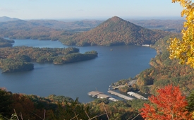
- Watauga Lake Area

Water recreation is abundant in this area, featuring Watauga Lake; the Doe, Elk and Watauga rivers; several streams and seven waterfalls.
Highly developed recreation areas along Watauga Lake provide facilities for fishing, picnicking, swimming and boat launching. The Appalachian National Scenic Trail runs through the area's backcountry. Camp on the lakeshore at Cardens Bluff or in the backcountry along Laurel Fork Creek at Dennis Cove.
- US 321/TN 67 Scenic Drive